Walking routes
This page contains links to some of our previous walk routes. There are now 140+ routes on the site, shown as pdf extracts from OS 1:25,000 or 1:50,000 maps.
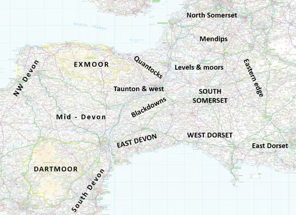
There are two ways to access them. The map below contains links to the older routes. We are working on a new map with more links, but it's a lot of work so please bear with us.
There's also a long list of routes by region (scroll down to find it). Identify the region you are interested in, browse the routes, and click on the relevant links.
If you are planning a walk on Exmoor, the Quantocks, north-west or mid-Devon this site may also be useful: it contains over 100 detailed walk instructions, many with alternative routes or ideas for linking walks together.
Note: The routes are provided as a record and for ideas only, and can't be guaranteed. They were OK at the time they were walked, but some are now very old. If you intend to use or adapt any of them for a future route please do a recce first (see the 'Leading walks' page). Some routes are on 1:25,000 or 1:12,500 base maps and a few of these are good enough to walk the route from (but beware - maps go out of date). Others are 1:50,000 and you will also need the relevant large-scale map.
Walk leaders - please send in your routes! If you have a route you would like to put on the map, please email it as a pdf, jpeg, gpx or trl file to Stan (or a photocopy with the route clearly marked). Include the starting-point, the length of the walk, and either the total amount of ascent or a subjective grade (easy, moderate, hilly, very strenuous).
Find routes on a map (routes up to 2018 only)
Use the map below to locate routes in the area that you are interested in. See below for the meaning of the different colours and symbols.
The walks are graded by colour:
- Yellow - less than 5 miles - these are suitable for short walks and may be suitable as evening walks (check the distance in relation how much time you have before it gets dark).
- Green - up to 9 miles, up to 300m of ascent or 350m if no steep sections (fairly gentle), straightforward terrain. We need more of these walks.
- Blue - these are up to 12 miles, no more than 700m of ascent (moderate to quite hilly), or have harder terrain. Most of our day walks fall into this category. Some can be shortened or the most hilly sections avoided, so don't dismiss them if you are looking for an easier walk.
- Black - these more strenuous walks can be over 12 miles, have more than 700m of ascent, or be on particularly difficult or tiring terrain.
- Red - danger! - these can be any length and level of difficulty, but require careful risk assessment and an experienced leader (e.g. open moorland walks, long sections of exposed cliff paths: see the 'safe walking' section). These need not be difficult walks in good conditions, but they can pose challenges in poor weather or if someone becomes injured.
In addition, the symbols mean:
- Bus - this is a linear walk that requires transport back to the start. The walk description normally says if there is a public bus or if you will need to hire a minibus or use cars. It's usually better to park at the finish and take the transport to the start, to avoid having to rush to meet the bus (or have a long wait to the next one).
- (i) - hazard! - read the notes - part of the walk is potentially hazardous - e.g. there is a section where there is vertigo risk, danger in wet weather/high winds, or some scrambling over difficult terrain. They don't need as much preparation as 'red' walks, but if you are leading one, alert people to the danger in the walk description, and have a contingency plan for bad weather, avoiding vertiginous sections etc.
List of routes with links
- Walks are grouped by region, as on the map below. Look under more than one region if you are planning a walk at the edge of a region, e.g. South Somerset and West Dorset for walks in the Crewkerne area.
- All walks have their length shown (in miles), and most have height gain (in metres). Open moorland, linear walks etc. are noted.
- Links take you to a pdf showing a map of the route and some brief details. A few have a link to more detailed instructions in the pdf.
|
Region |
Name |
Date |
Miles |
+/- (m) |
Link (most links are to an outline map, some routes also have links to detailed instructions) |
|
South Devon |
|
|
|
|
|
|
South Devon |
Dartmouth, Dittisham & Kingswear |
2025 |
9.5 |
675 |
|
|
Dartmoor |
|
|
|
|
|
|
Dartmoor |
Two Bridges & Rough Tor (open moorland) |
pre-2018 |
8.3 |
335 |
http://footloose303.emyspot.com/medias/files/two-bridges.pdf |
|
Dartmoor |
Around Dartmeet (open moorland) |
pre-2018 |
7.6 |
? |
http://footloose303.emyspot.com/medias/files/around-dartmeet.pdf |
|
Dartmoor |
Hay Tor & Hound Tor (open moorland) |
pre-2018 |
10 |
550 |
http://footloose303.emyspot.com/medias/files/hay-tor-and-hound-tor.pdf |
|
Dartmoor |
Meldon & Hookney (near Chagford) (open moorland) |
pre-2018 |
9 |
440 |
http://footloose303.emyspot.com/medias/files/meldon-hookney.pdf |
|
Dartmoor |
Okehampton (from station) & Belstone (open moorland) |
2025 |
8.2 |
460 |
|
|
Dartmoor |
Around Dartmeet (open moorland) |
pre-2018 |
7.6 |
? |
http://footloose303.emyspot.com/medias/files/around-dartmeet.pdf |
|
Dartmoor |
Hay Tor & Hound Tor (open moorland) |
pre-2018 |
10 |
550 |
http://footloose303.emyspot.com/medias/files/hay-tor-and-hound-tor.pdf |
|
Dartmoor |
Hay Tor & Rippon Tor |
2025 |
7.4 |
390 |
|
|
Dartmoor |
Postbridge & Bellever Tor (open moorland) |
pre-2018 |
8.5 |
? |
http://footloose303.emyspot.com/medias/files/postbridge-and-bellever-tor.pdf |
|
Dartmoor |
Castle Drogo Teign Gorge short walk |
2026 |
4.4 |
300 |
http://footloose303.emyspot.com/medias/files/castledrogo.pdf |
|
NW Devon |
|
|
|
|
|
|
NW Devon |
Hartland Point & Quay |
2023 |
8 |
585 |
|
|
NW Devon |
Exmansworthy & Clovelly |
2023 |
8.7 |
600 |
http://footloose303.emyspot.com/medias/files/exmansworthy-clovelly.pdf |
|
NW Devon |
Croyde & Baggy Point |
2022 |
8.5 |
400 |
http://footloose303.emyspot.com/medias/files/croyde-baggy.pdf |
|
NW Devon |
Mortehoe & Lee |
2022 |
7.2 |
550 |
http://footloose303.emyspot.com/medias/files/mortehoe-lee.pdf |
|
NW Devon |
Ilfracombe & Lee |
2024 |
9.1 |
500 |
http://footloose303.emyspot.com/medias/files/ilfracombe-lee.pdf |
|
NW Devon |
Berrynarbor & Hele |
2024 |
7.7 |
450 |
http://footloose303.emyspot.com/medias/files/berrynarbor-hele.pdf |
|
NW Devon |
Around Combe Martin |
2021 |
8 |
620 |
http://footloose303.emyspot.com/medias/files/combe-martin.pdf |
|
Exmoor |
|
|
|
|
|
|
Exmoor coast |
Hunters Inn & Holdstone Down |
2024 |
9 |
720 |
http://footloose303.emyspot.com/medias/files/hunters-holdstone.pdf |
|
Exmoor coast |
Lynton & Woody Bay |
2022 |
9.7 |
950 |
http://footloose303.emyspot.com/medias/files/lynton-woody-bay.pdf |
|
Exmoor coast |
Lynton, Lynmouth & Valley of the Rocks |
pre-2018 |
5.6 |
560 |
http://footloose303.emyspot.com/medias/files/valley-of-the-rocks.pdf |
|
Exmoor |
Lyn gorges, Countisbury & Valley of Rocks |
2023 |
9 |
830 |
|
|
Exmoor coast |
Oare, County Gate & Culbone |
pre-2018 |
9.1 |
790 |
http://footloose303.emyspot.com/medias/files/oare-culbone-and-county-gate.pdf |
|
Exmoor |
Doone Valley from Robber’s Bridge |
pre-2018 |
10 |
530 |
http://footloose303.emyspot.com/medias/files/doone-valley-from-robbers-bridge.pdf |
|
Exmoor coast |
Porlock, Hawk Combe & Culbone |
pre-2018 |
10.3 |
600 |
http://footloose303.emyspot.com/medias/files/porlock-hawk-combe-and-culbone.pdf |
|
Exmoor |
Bossington, Selworthy & Allerford |
pre-2018 |
7 |
625 |
|
|
Exmoor |
Selworthy, Bossington Hill & Bratton Ball |
2023 |
9.8 |
615 |
|
|
Exmoor |
Challacombe (open moorland) |
pre-2018 |
9.7 |
400 |
http://footloose303.emyspot.com/medias/files/challacombe.pdf |
|
Exmoor |
Simonsbath, Cow Castle & Cornham |
pre-2018 |
8.2 |
355 |
http://footloose303.emyspot.com/medias/files/simonsbath-cow-castle.pdf |
|
Exmoor |
Exford & Withypool |
pre-2018 |
8 |
420 |
http://footloose303.emyspot.com/medias/files/exford-and-withypool.pdf |
|
Exmoor |
Withypool & Lanacre Gate |
pre-2018 |
8 |
330 |
http://footloose303.emyspot.com/medias/files/withypool-lanacre-gate.pdf |
|
Exmoor |
Molland & Anstey Common |
pre-2018 |
8.5 |
420 |
|
|
Exmoor |
Horner & Dunkery |
pre-2018 |
10 |
615 |
http://footloose303.emyspot.com/medias/files/horner-and-dunkery.pdf |
|
Exmoor |
Wheddon Cross to Dulverton (linear, bus) |
pre-2018 |
10.5 |
510 |
http://footloose303.emyspot.com/medias/files/wheddon-x-dulverton.pdf |
|
Exmoor |
North from Dulverton |
2017 |
9.3 |
540 |
http://footloose303.emyspot.com/medias/files/north-from-dulverton.pdf |
|
Exmoor |
Dulverton and the Barle |
pre-2018 |
7.5 |
500 |
http://footloose303.emyspot.com/medias/files/dulverton-and-the-barle.pdf |
|
Exmoor |
Dulverton, Hawkridge & the Barle |
2022 |
10.7 |
550 |
http://footloose303.emyspot.com/medias/files/dulverton-hawkridge.pdf |
|
Exmoor |
Wimbleball Hub & Bury |
2025 |
8 |
420 |
http://footloose303.emyspot.com/medias/files/wimbleball-and-bury.pdf |
|
Exmoor |
Wheddon Cross to Dunster via Lype Hill & Clicket (linear, bus) |
pre-2018 |
10.5 |
415 |
http://footloose303.emyspot.com/medias/files/wheddon-x-to-dunster-via-clicket.pdf |
|
Exmoor |
Woods above Dunster |
pre-2018 |
9.8 |
630 |
http://footloose303.emyspot.com/medias/files/woods-above-dunster.pdf |
|
Exmoor |
Carhampton & Dunster woods |
pre-2018 |
8.5 |
540 |
|
|
Exmoor |
Minehead, Dunster & the Grabbist ridge |
2024 |
10 |
350 |
|
|
Exmoor coast |
Watchet to Minehead (linear using bus or train) |
2025 |
7.8 |
165 |
http://footloose303.emyspot.com/medias/files/watchet-minehead.pdf |
|
Exmoor |
Around Luxborough |
2019 |
9 |
500 |
|
|
Exmoor |
Roadwater & Monksilver |
pre-2018 |
8 |
500 |
http://footloose303.emyspot.com/medias/files/roadwater-and-monksilver.pdf |
|
Quantocks |
|
|
|
|
|
|
Quantocks |
Holford & Kilve |
2025 |
10 |
450 |
http://footloose303.emyspot.com/medias/files/holford-kilve.pdf |
|
Quantocks |
Holford & northern Quantocks |
pre-2018 |
10.7 |
600 |
http://footloose303.emyspot.com/medias/files/holford-northern-quantocks.pdf |
|
Quantocks |
Holford & northern Quantocks longer |
pre-2018 |
12.4 |
630 |
http://footloose303.emyspot.com/medias/files/holford-and-northern-quantocks-longer.pdf |
|
Quantocks |
Dead Woman’s Ditch & Bicknoller |
2025 |
8 |
355 |
|
|
Quantocks |
Bicknoller & Weacombe |
pre-2018 |
8.5 |
650 |
|
|
Quantocks |
Bicknoller harder walk |
pre-2018 |
9.6 |
890 |
http://footloose303.emyspot.com/medias/files/bicknoller-alternative.pdf |
|
Quantocks |
Bicknoller & Somerton Combe |
2025 |
9 |
515 |
http://footloose303.emyspot.com/medias/files/bicknoller-somerton.pdf |
|
Quantocks |
Crowcombe, Triscombe & Bicknoller |
2025 |
13 |
815 |
http://footloose303.emyspot.com/medias/files/crowcombe13.pdf |
|
Quantocks |
Triscombe & Holford |
pre-2018 |
8.6 |
490 |
http://footloose303.emyspot.com/medias/files/triscombe-and-holford.pdf |
|
Quantocks |
Triscombe & Aisholt |
2017 |
7.5 |
470 |
http://footloose303.emyspot.com/medias/files/triscombe-and-aisholt.pdf |
|
Quantocks |
West Bagborough, Aisholt & Cothelstone |
pre-2018 |
9.7 |
615 |
http://footloose303.emyspot.com/medias/files/w-bagborough-aisholt-cothelstone.pdf |
|
Quantocks |
Fyne Court, Goathurst & Enmore |
pre-2018 |
7.6 |
285 |
http://footloose303.emyspot.com/medias/files/fyne-court-goathurst-and-enmore.pdf |
|
Quantocks |
Fyne Court & Cothelstone Hill |
pre-2018 |
6.3 |
350 |
http://footloose303.emyspot.com/medias/files/fyne-court-cothelstone.pdf |
|
Quantocks |
Kingston St Mary & Cothelstone |
2025 |
8 |
390 |
http://footloose303.emyspot.com/medias/files/kingston-cothelstone.pdf |
|
Quantocks |
Fyne Court & Kingston St Mary |
pre-2018 |
7.7 |
325 |
http://footloose303.emyspot.com/medias/files/fyne-court-kingston-st-mary.pdf |
|
Quantocks |
Kingston St Mary & Norton Camp |
2024 |
8.2 |
150 |
http://footloose303.emyspot.com/medias/files/kingston-norton-camp.pdf |
|
Taunton & west |
|
|
|
|
|
|
Taunton & west |
Orchard Portman & Trull |
pre-2018 |
7 |
115 |
http://footloose303.emyspot.com/medias/files/orchard-portman-and-trull.pdf |
|
Taunton & west |
Wellington to Taunton (Grand Western Greenway) (linear using bus) |
2024 |
8.7 |
60 |
http://footloose303.emyspot.com/medias/files/wellington-taunton.pdf |
|
Taunton & west |
Wellington & Westford |
pre-2018 |
9.8 |
190 |
|
|
Taunton & west |
Wellington & Langford Budville |
pre-2018 |
9.4 |
220 |
http://footloose303.emyspot.com/medias/files/wellington-langford-budville.pdf |
|
Taunton & west |
Around Milverton |
pre-2018 |
8.3 |
285 |
|
|
Taunton & west |
Langford Budville & Stawley |
pre-2018 |
10 |
320 |
http://footloose303.emyspot.com/medias/files/langford-budville.pdf |
|
Taunton & west |
Langford Heathfield, Bathealton & Kittisford |
pre-2018 |
10.2 |
385 |
http://footloose303.emyspot.com/medias/files/langford-heathfield.pdf |
|
Taunton & west |
Wiveliscombe, Washbattle & Waterrow |
2024 |
9 |
500 |
http://footloose303.emyspot.com/medias/files/wivey-hurstone.pdf |
|
Taunton & west |
Wiveliscombe & Heydon Hill |
2022 |
8.1 |
520 |
http://footloose303.emyspot.com/medias/files/wiveyheydon.pdf |
|
Taunton & west |
Wellington & the Monument |
2024 |
6.3 |
235 |
http://footloose303.emyspot.com/medias/files/wellington-monument.pdf |
|
Mid-Devon |
|
|
|
|
|
|
Mid-Devon |
Tiverton canal walk |
2025 |
8.5 |
125 |
http://footloose303.emyspot.com/medias/files/tiverton-canal-walk.pdf |
|
Mid-Devon |
Witheridge |
2023 |
9 |
265 |
|
|
Mid-Devon |
Bampton & Cove |
2022 |
7.7 |
400 |
http://footloose303.emyspot.com/medias/files/bampton-cove.pdf |
|
Mid-Devon |
Bampton & Clayhanger |
2021 |
11 |
430 |
http://footloose303.emyspot.com/medias/files/bampton-clayhanger.pdf |
|
Mid-Devon |
Knightshayes short walk |
2026 |
4.3 |
190 |
http://footloose303.emyspot.com/medias/files/knightshayes.pdf |
|
Blackdowns |
|
|
|
|
|
|
Blackdowns |
Taunton & Corfe |
pre-2018 |
9 |
150 |
http://footloose303.emyspot.com/medias/files/taunton-and-corfe.pdf |
|
Blackdowns |
Stoke St Mary & Thurlbear short walk |
pre-2018 |
3.2 |
100 |
http://footloose303.emyspot.com/medias/files/stoke-st-mary-thurlbear.pdf |
|
Blackdowns |
Alt Stoke & Thurlbear |
pre-2018 |
5.2 |
175 |
http://footloose303.emyspot.com/medias/files/stoke-thurlbear.pdf |
|
Blackdowns |
Staple Fitzpaine short walk |
pre-2018 |
3 |
75 |
http://footloose303.emyspot.com/medias/files/staple-fitzpaine-short.pdf |
|
Blackdowns |
Slough Green short walk |
pre-2018 |
2.7 |
70 |
http://footloose303.emyspot.com/medias/files/slough-green-short-walk.pdf |
|
Blackdowns |
Churchstanton |
pre-2018 |
7.6 |
280 |
http://footloose303.emyspot.com/medias/files/churchstanton.pdf |
|
Blackdowns |
Castlle Neroche & Bishopswood |
2025 |
8.5 |
315 |
http://footloose303.emyspot.com/medias/files/nerochesouth.pdf |
|
Blackdowns |
Culmstock & Uffculme: Culm Valley |
pre-2018 |
7 |
? |
http://footloose303.emyspot.com/medias/files/culm-valley.pdf |
|
Blackdowns |
Uffculme, Culmstock & Ashill |
2023 |
8.2 |
250 |
|
|
Blackdowns |
South from Hemyock |
pre-2018 |
8.2 |
325 |
http://footloose303.emyspot.com/medias/files/south-from-hemyock.pdf |
|
Blackdowns |
Stentwood & Hemyock |
pre-2018 |
7.8 |
? |
http://footloose303.emyspot.com/medias/files/stentwood-hemyock-area-.pdf |
|
Blackdowns |
Stentwood & Madford Valley |
2024 |
10 |
425 |
http://footloose303.emyspot.com/medias/files/stentwood-madford.pdf |
|
Blackdowns |
Smeatharpe & Bolham River |
pre-2018 |
8.7 |
315 |
|
|
Blackdowns |
Smeatharpe & Mackham Farms |
pre-2018 |
8.7 |
200 |
http://footloose303.emyspot.com/medias/files/smeatharpe-2.pdf |
|
Blackdowns |
North from Dunkeswell |
pre-2018 |
9.3 |
400 |
|
|
Blackdowns |
NE from Dunkeswell |
2024 |
8.8 |
275 |
http://footloose303.emyspot.com/medias/files/dunkeswellne.pdf |
|
Blackdowns |
Otterhead & Churchinford short walk |
pre-2018 |
3.1 |
90 |
|
|
Blackdowns |
Broadhembury & Blackborough Common |
pre-2018 |
10.2 |
? |
http://footloose303.emyspot.com/medias/files/broadhembury.pdf |
|
Blackdowns |
Howley & Wambrook |
pre-2018 |
10 |
435 |
http://footloose303.emyspot.com/medias/files/howley-and-wambrook.pdf |
|
East Devon |
|
|
|
|
|
|
East Devon |
Around Stockland & River Yarty |
pre-2018 |
9.5 |
? |
http://footloose303.emyspot.com/medias/files/stockland-r-yarty.pdf |
|
East Devon |
Kentisbeare & Blackborough |
pre-2018 |
9 |
330 |
http://footloose303.emyspot.com/medias/files/kentisbeare.pdf |
|
East Devon |
Yarty Valley & Stockland Hill |
pre-2018 |
10 |
475 |
http://footloose303.emyspot.com/medias/files/yarty-valley.pdf |
|
East Devon |
Yarcombe & Stockland |
pre-2018 |
8.7 |
315 |
|
|
East Devon |
Around Dalwood |
pre-2018 |
9.5 |
? |
|
|
East Devon |
Chardstock & Wambrook |
pre-2018 |
8 |
340 |
|
|
East Devon |
Chardstock short walk |
pre-2018 |
3 |
140 |
http://footloose303.emyspot.com/medias/files/chardstock-short-walk.pdf |
|
East Devon coast |
Ebford to Exmouth (linear, bus) |
pre-2018 |
6.5 |
100 |
http://footloose303.emyspot.com/medias/files/ebford-to-exmouth.pdf |
|
East Devon |
Newton Poppleford & Colaton Raleigh |
pre-2018 |
9.6 |
265 |
http://footloose303.emyspot.com/medias/files/newton-poppleford.pdf http://footloose303.emyspot.com/medias/files/newton-poppleford-additional.pdf |
|
East Devon coast |
Otterton from Budleigh Salterton |
pre-2018 |
7.5 |
250 |
|
|
East Devon coast |
Beer to Sidmouth (linear, bus) |
pre-2018 |
9.3 |
730 |
http://footloose303.emyspot.com/medias/files/beer-to-sidmouth.pdf |
|
East Devon |
North from Colyton |
pre-2018 |
8.8 |
220 |
|
|
East Devon coast |
Seaton to Lyme (linear, uses bus) |
pre-2018 |
7.5 |
450 |
http://footloose303.emyspot.com/medias/files/seaton-to-lyme.pdf |
|
East Devon |
Uplyme from Trinity Hill |
2025 |
7.5 |
300 |
|
|
West Dorset |
|
|
|
|
|
|
West Dorset coast |
Lamberts Castle to Charmouth |
2026 |
10.3 |
390 |
http://footloose303.emyspot.com/medias/files/lamberts-castle-charmouth.pdf |
|
West Dorset coast |
Charmouth, Morecombelake & Golden Cap |
pre-2018 |
10 |
450 |
http://footloose303.emyspot.com/medias/files/charmouth-morecombelake-golden-cap.pdf |
|
West Dorset coast |
Stonebarrow Hill & Seatown |
2024 |
9 |
585 |
http://footloose303.emyspot.com/medias/files/stonebarrow-seatown.pdf |
|
West Dorset |
Liberty Trail III – Thorncombe to Lyme (linear) |
pre-2018 |
10.5 |
? |
http://footloose303.emyspot.com/medias/files/liberty-3-thorncombe-lyme.pdf |
|
West Dorset |
Kingcombe, Toller Porcorum & Powerstock |
pre-2018 |
12 |
? |
http://footloose303.emyspot.com/medias/files/kingcombe-walk.pdf |
|
West Dorset |
Jubilee Trail I – Forde Abbey to Stoke Abbot (linear) |
pre-2018 |
9.5 |
415 |
http://footloose303.emyspot.com/medias/files/jubilee-trail-1-forde-abbey-to-stoke-abbott.pdf |
|
West Dorset |
Jubilee Trail II – Stoke Abbott to Kingcombe (linear) |
pre-2018 |
9.6 |
350 |
http://footloose303.emyspot.com/medias/files/jubilee-trail-2-stoke-abbott-to-kingcombe.pdf |
|
West Dorset |
Jubilee Trail III – Kingcombe to Hardy’s Monument (linear) |
pre-2018 |
10.7 |
400 |
http://footloose303.emyspot.com/medias/files/jubilee-trail-3-kingcombe-to-hardys-monument.pdf |
|
West Dorset |
Jubilee Trail IV - Hardy’s Monument to West Knighton (linear) |
pre-2018 |
11 |
290 |
http://footloose303.emyspot.com/medias/files/hardy-s-monument-to-west-knighton.pdf |
|
West Dorset |
Dorchester to Weymouth (linear, train) |
pre-2018 |
9.5 |
240 |
http://footloose303.emyspot.com/medias/files/dorchester-to-weymouth.pdf Descr: http://footloose303.emyspot.com/medias/files/dorchester-weymouth-description.pdf |
|
West Dorset |
Kingcombe |
2025 |
8 |
310 |
|
|
West Dorset |
Broadwindsor & Pilsdon Pen |
pre-2018 |
8.6 |
430 |
http://footloose303.emyspot.com/medias/files/broadwindsor-pilsdon-pen.pdf |
|
West Dorset |
Broadwindsor & Stoke Abbott |
2024 |
7.7 |
400 |
http://footloose303.emyspot.com/medias/files/broadwindsor2.pdf |
|
West Dorset |
West from Beaminster |
pre-2018 |
9 |
? |
|
|
West Dorset |
Beaminster & Netherbury |
2024 |
7.6 |
240 |
http://footloose303.emyspot.com/medias/files/beaminster2.pdf |
|
West Dorset |
Cattistock |
pre-2018 |
7.3 |
? |
http://footloose303.emyspot.com/medias/files/cattistock-2.pdf |
|
West Dorset |
Winyard’s Gap & Corscombe |
pre-2018 |
7.4 |
290 |
http://footloose303.emyspot.com/medias/files/winyards-gap.pdf http://footloose303.emyspot.com/medias/files/winyards-gap-additional.pdf |
|
West Dorset |
Oathill, Pilsdon Pen & Blackdown Hill |
pre-2018 |
10.2 |
? |
http://footloose303.emyspot.com/medias/files/oathill-and-pilsdon-pen.pdf |
|
West Dorset |
Circuit from Oathill |
pre-2018 |
7.4 |
190 |
http://footloose303.emyspot.com/medias/files/circuit-from-oathill.pdf |
|
West Dorset |
Another Oathill walk |
pre-2018 |
10.8 |
? |
http://footloose303.emyspot.com/medias/files/alternative-oathill.pdf |
|
West Dorset |
Winsham & Blackdown Hill |
pre-2018 |
11.2 |
340 |
http://footloose303.emyspot.com/medias/files/winsham-area.pdf |
|
West Dorset |
Forde Abbey, Thorncombe & Blackdown Hill |
pre-2018 |
5.9 |
? |
http://footloose303.emyspot.com/medias/files/forde-abbey-and-blackdown-hill.pdf |
|
|
|
|
|
|
|
|
East Dorset |
Jubilee Trail V – West Knighton to Briantspuddle (linear) |
pre-2018 |
9.8 |
190 |
http://footloose303.emyspot.com/medias/files/west-knighton-to-briantspuddle.pdf |
|
South Somerset |
|
|
|
|
|
|
South Som |
Curry Mallet & Hatch Beauchamp |
pre-2018 |
8.3 |
150 |
http://footloose303.emyspot.com/medias/files/curry-mallet.pdf |
|
South Som |
Bowdens Farm nr Hambridge |
pre-2018 |
10.3 |
100 |
http://footloose303.emyspot.com/medias/files/bowdens-farm-hambridge-area-.pdf |
|
South Som |
Cricket St Thomas |
pre-2018 |
7.8 |
350 |
http://footloose303.emyspot.com/medias/files/cricket-st-thomas.pdf |
|
South Som |
Ilminster, Chaffcombe & Chillington |
pre-2018 |
11.3 |
400 |
http://footloose303.emyspot.com/medias/files/south-from-ilminster.pdf |
|
South Som |
Ilminster & Chard Resr |
pre-2018 |
8.5 |
200 |
http://footloose303.emyspot.com/medias/files/ilminster-to-chard-reservoir.pdf |
|
South Som |
Kingsbury Episcopi & the Lambrooks |
pre-2018 |
9.5 |
125 |
http://footloose303.emyspot.com/medias/files/kingsbury-lambrooks.pdf |
|
South Som |
Shepton Beauchamp & Lambrooks short walk |
pre-2018 |
5 |
? |
http://footloose303.emyspot.com/medias/files/shepton-beauchamp-lambrooks.pdf |
|
South Som |
Around Langport |
2025 |
7.7 |
130 |
|
|
South Som |
Pitney & High Ham |
2025 |
10.2 |
200 |
|
|
South Som |
South Petherton & Kingsbury Episcopi |
pre-2018 |
8.7 |
140 |
http://footloose303.emyspot.com/medias/files/s-petherton-kingsbury.pdf |
|
South Som |
Ham Hill, Montacute & Odcombe |
2016 |
10.4 |
? |
http://footloose303.emyspot.com/medias/files/ham-hill-montacute-odcombe.pdf |
|
South Som |
Norton, Chiselborough & Montacute |
2024 |
9.1 |
320 |
http://footloose303.emyspot.com/medias/files/norton.jpg |
|
South Som |
Ham Hill & Chiselborough |
pre-2018 |
8 |
280 |
http://footloose303.emyspot.com/medias/files/ham-hill-and-chiselborough.pdf |
|
South Som |
Ham Hill, East & Middle Chinnock |
2011 |
8 |
300 |
|
|
South Som |
Liberty Trail I – Ham Hill to Crewkerne (linear) |
pre-2018 |
9.5 |
? |
http://footloose303.emyspot.com/medias/files/liberty-1-ham-hill-to-crewkerne.pdf |
|
South Som |
Liberty Trail II – Crewkerne to Thorncombe (linear) |
pre-2018 |
10 |
? |
http://footloose303.emyspot.com/medias/files/liberty-2-crewkerne-thorncombe.pdf |
|
South Som |
Leland Trail II – Castle Cary to w Camel (linear) |
pre-2018 |
10.4 |
? |
http://footloose303.emyspot.com/medias/files/castle-cary-w-camel-leland-part-2-.pdf |
|
South Som |
Leland Trail III – West Camel to Ham Hill (linear) |
pre-2018 |
10.4 |
? |
http://footloose303.emyspot.com/medias/files/liberty-1-ham-hill-to-crewkerne.pdf |
|
Levels & moors |
|
|
|
|
|
|
Levels & moors |
Combwich & Steart |
pre-2018 |
9.9 |
90 |
http://footloose303.emyspot.com/medias/files/combwich-steart.pdf |
|
Levels & moors |
Creech St Michael short walk |
pre-2018 |
4.8 |
min |
http://footloose303.emyspot.com/medias/files/creech-short.pdf |
|
Levels & moors |
Meare Green & North Curry |
pre-2018 |
7.7 |
110 |
http://footloose303.emyspot.com/medias/files/meare-green.pdf |
|
Levels & moors |
Aller & Burrowbridge |
pre-2018 |
8 |
50 |
http://footloose303.emyspot.com/medias/files/aller-burrowbridge.pdf |
|
Levels & moors |
Athelney & rivers Tone & Parrett |
pre-2018 |
7.8 or 10 |
75 |
http://footloose303.emyspot.com/medias/files/athelney-r-tone.pdf |
|
Levels & moors |
Compton Dundon |
2025 |
7.8 |
270 |
http://footloose303.emyspot.com/medias/files/comptondundon.pdf |
|
Levels & moors |
Shapwick Heath |
pre-2018 |
8 |
min |
http://footloose303.emyspot.com/medias/files/shapwick-heath.pdf |
|
Levels & moors |
Wedmore |
2024 |
9.3 |
175 |
|
|
Levels & moors |
Westhay Moor & Wedmore |
pre-2018 |
8.5 |
145 |
http://footloose303.emyspot.com/medias/files/westhay-wedmore.pdf |
|
Mendips |
|
|
|
|
|
|
Mendips |
Wavering Down & Crook Peak |
2025 |
7.8 |
400 |
http://footloose303.emyspot.com/medias/files/wavering-down.pdf |
|
Mendips |
Charterhouse, Velvet Bottom & Beacon Batch |
2025 |
8.4 |
295 |
http://footloose303.emyspot.com/medias/files/charterhouse.pdf |
|
Mendips |
Cheddar, Velvet Bottom & Beacon Batch |
2022 |
10 |
450 |
http://footloose303.emyspot.com/medias/files/cheddar-beacon-batch.pdf |
|
Mendips |
Cheddar Gorge & Velvet Bottom |
pre-2018 |
10.1 |
450 |
http://footloose303.emyspot.com/medias/files/cheddar-gorge.pdf |
|
Mendips |
Cheddar Gorge & Draycott |
pre-2018 |
11.7 |
725 |
http://footloose303.emyspot.com/medias/files/cheddar-gorge-and-draycott.pdf |
|
Mendips |
Cheddar & Rodney Stoke |
pre-2018 |
11.1 |
875 |
http://footloose303.emyspot.com/medias/files/cheddar-and-rodney-stoke.pdf |
|
Mendips |
Cheddar Gorge & Beacon Batch |
pre-2018 |
12 |
600 |
http://footloose303.emyspot.com/medias/files/cheddar-and-beacon-batch.pdf |
|
Mendips |
Wells and Cheddar circuit |
pre-2018 |
12 |
625 |
http://footloose303.emyspot.com/medias/files/wells-to-cheddar.pdf |
|
Mendips |
Wells eastwards |
pre-2018 |
10.5 |
280 |
http://footloose303.emyspot.com/medias/files/wells-eastern-mendips.pdf |
|
Mendips |
Burrington, Beacon Batch & Dolebury Warren |
pre-2018 |
7.5 |
450 |
http://footloose303.emyspot.com/medias/files/above-burrington.pdf |
|
Mendips |
Ebbor Gorge & Wookey Hole |
2025 |
7.5 |
550 |
http://footloose303.emyspot.com/medias/files/ebbor-wookey.pdf |
|
Mendips |
Litton & Hinton Blewett |
pre-2018 |
10.7 |
270 |
http://footloose303.emyspot.com/medias/files/litton.pdf http://footloose303.emyspot.com/medias/files/litton-additional.pdf |
|
Mendips |
Edford & Harridge Woods |
pre-2018 |
6 |
175 |
http://footloose303.emyspot.com/medias/files/harridge-woods.pdf |
|
Mendips |
Nettlebridge & Stoke St Michael |
pre-2018 |
11 |
330 |
http://footloose303.emyspot.com/medias/files/nettlebridge.pdf |
|
Mendips |
Cranmore |
pre-2018 |
11.1 |
360 |
|
|
Mendips |
The Pennards |
2025 |
9.7 |
290 |
|
|
Eastern edge |
|
|
|
|
|
|
Eastern edge |
Bourton, Stourhead & Alfreds Tower |
pre-2018 |
10.3 |
350 |
http://footloose303.emyspot.com/medias/files/bourton-and-stourhead.pdf |
|
Eastern edge |
Leland Trail I – K. Alfred’s Tower to Castle Cary (linear) |
pre-2018 |
10 |
? |
http://footloose303.emyspot.com/medias/files/k-alfred-to-castle-cary-leland-part-1-.pdf |
|
Eastern edge |
Castle Cary |
2024 |
10 |
160 |
|
|
Eastern edge |
East from Shaftesbury |
pre-2018 |
8.8 |
270 |
http://footloose303.emyspot.com/medias/files/shaftesbury.pdf |
Last edited: 12/04/2026
Walk - Bridport - Helen
SUNDAY. Helen T will lead a walk from Bradpole near Bridport via Walditch to West Bay. Approx 9/10 miles easy/moderate walking along rivers and tracks ...

Upcoming walks and gaps
No gaps until June. Upcoming walks are: 14th June - leader needed 21st June - Paula C - Raodwater - awaiting details Contact Helen or Paula ...

Walk leader needed please
Hello everyone - I try not to put this picture on..... but if anyone has a walk they would like to do on this weekend (13th or 14th June) then Paula or ...